 People are shocked when they learn that two geeks like us don’t have a GPS. But we just don’t like the thought of having one more electronic gadget to occupy space in our minds, and dealing with the idiosyncrasies and upgrades that usually accompany them. A cell phone is bad enough.
So, how do we find our way through this great big continent without a GPS? Paper maps! Imagine that! They don’t need batteries or uploading, they usually make it obvious enough to tell which roads are decent enough for our rig to travel on, and they don’t need upgrading unless you spill your coffee on them.
For general navigation through North America, I use a notebook-sized Rand McNally Road Map that has just enough detail to show us secondary roads that can get us off the Interstates. But when we want to get off the beaten path and travel the blue highways, I’ll use state-specific maps, which we rarely pay for. We get the most current versions for free at welcome centers on the Interstate, Chamber of Commerce offices, and tourism bureaus.
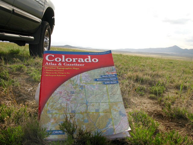
For our extended stays in any state, one of the best navigation systems we have is our trusty Gazeteer Atlas. There’s a Gazeteer for every state in the nation, at around $20 each. They’re especially useful for cheapskate wanderers like us, as they show topography, designate between public and private lands, recreation spots, campgrounds (private and public), and include other handy tips for getting around.
Save On Gazeteer Maps at Amazon!
Over the last three years on the road, there’s only been a few occasions where a GPS really would’ve helped us. But all in all, even when things don’t go according to plan and we end up going miles out of our way on some Forest Service road, there’s a sense of danger and adventure in those travels that are the stuff memories are made of. If you’re never really lost with a GPS, what fun is that?
One time we were approached at a state line truck stop by an elderly RVer who asked, “Do you know how to change states on the GPS?” We’ll take our paper maps any day. How about you?
Not sure how I missed this post. I love my GPS but the Gazetteer’s are the best state by State maps avail. Kim loves these and hates the GPS. Her California Gazetteer is very worn and tattered, I want to replace it but she takes notes of all the cool places we visit in the margins of the maps. Too much info to copy over to a new one. We get one of these for each new state we visit, love them.
i’m a paper map geek.
these are MUCH better than delorme!
western states only.
Benchmark Maps
Hey Rene….can’t get away from me!
No GPS here either. Aside from the typical road navigation type, I think finding your way successfully with nothing but a map and a compass is a lost art. Orienteering they called it when I was a boy scout. I think people should learn to read a map and do it well, because a map will never fail you.
I just refuse to leave my trip making up to batteries and electronic whizzboombangs. 🙂
If we meet up somewhere, I’ll have to show you the map cabinet. It’s ridiculous.
Ah ha ha, I have to show this to Sean. 🙂 I HATE maps. Mainly because of the folding. I love my Google Maps on my phone and he even has Garmond on his. But alas, I’ve been schooled that I must learn to read a “real” map. I’ll make sure to tell him he was right. 🙂
I see Cindi has already commented but I’ll ring in also.. I think each has its place. I find with GPS, I don’t look at my surroundings as much. I like the idea of coordinates and direction alot.. Its good in-town for clogged city streets but, however, not always accurate..Only as good as the input data… Paper maps / Altlas’s / Gazetteer’s are fun..You get that spacial orientation like flying..what’s that mountain over there-type of fun.. I make my twice a year pilgrimage to Delorme in Maine ( 43.80775n, 70.163269w ) and drool..
“A road map always tells you everything except how to refold it”
Mike in high pollen count (at least today) Eureka (Geographer before GPS)
http://www.youtube.com/watch?v=0gNA8-OusKs&feature=player_embedded
Hard to believe that you two geeks don’t use a GPS. We use Streets and Trips on our old IBM T21 laptop (laptop from 2001 if you can believe it). We like the larger screen. We use discoveryowners.com to import map overlays of points of interest like service stations, Walmarts, etc. And if needed, can check email. But, we always verify the route because “Gloria”, (our pet name for the GPS), sometimes wants to take us down some weird routes.
I love the way you and others are pointing out the different ways they integrate technology on their routes, thank you!
Of course we like paper maps. I think the Google maps on the computer and the GPS are too weird and don’t give you enough info. Gotta love a good geographer eh?
Cheers!
I knew you’d be with us on that one Mike!
No GPS for us, though we have been using our iPhones more often when we’re just going a short distance, to figure out all of the Left at Main Street kind of stuff.
But for longer trips, I’m all about the Atlas. Somehow I feel like (and no offense to anyone who chooses differently!) that letting a computer tell me how to get from here to there is kind of defeating the point of exploring…even a bit emasculating. I’ve never been one to not stop for directions because I’m too macho or anything, but I’m pretty sure the Matrix and Terminators all started with GPS……
You crack me up! I think if I had an iPhone I might use it that way too. Now stop tempting me to get one.
Shane’s phone comes standard with GPS if we need it, but we LOVE our paper maps. In fact we’ve got almost a whole bookshelf devoted to maps, many of them old crinkled Gazeteer’s.
We LOOOOVE our GPS 🙂 Dealing with paper maps AND trying to be present/parenting a 4 year old while driving in bumper to bumper traffic was extremely stressful. Matt and I never fight, but it seemed that we were MUCH more tense and cranky at each other when the GPS was broken!
I do love looking at paper maps though! 🙂
I hear ya on that. If we had a munchkin who needed entertaining while we were going on down the road, I’d be the first one to get a GPS!
We bought ourselves the National Geographic Road Atlas: RV & Camping Edition couple years before we even decided to go full time RVing. We still use it today when we are crossing states. Though, when we are in the city, I always use our laptop and connect to our Verizon Broadband to navigate with Google Maps. I am the human GPS, we like to call it.
I might attempt to use Google Maps that way, if I wasn’t so busy knitting when we are moving!
We’re actually in the middle of researching a GPS.. but not so much for traditional guidance. We use a combination of paper maps and tour books to find interesting routes, and let serendipity navigate us.
However, our iPhone’s maps and GPS come in quite handy when we need to be someplace, such as routing to a friend’s house, finding a restaurant, etc. And, there are occasional times when that doesn’t work due to no cell coverage.
So, we’re contemplating a dedicated GPS system – mainly as a backup in case of no cell signal. But also to record our tracking so I don’t have to hand create maps that show where we’ve been (something I love having to should folks.)
It’s also helpful for the driver to have easily accessible maps showing what is around. A lot of times the passenger in our vehicle is working while we’re in motion and can’t be an ‘on call’ navigator.
Yeah, there’s been a few times when we were stuck in less than desirable places trying to find our way out. A GPS might have saved us from being stressed out on more than one occasion.
No GPS for us. My wife and I do all our road tripping with maps and atlases. And we swear by the Gazeteer’s by DeLorme. One time in our home state, my wife was giving me directions from the Gazeteer. I kid you not, she said the following, “You’re gonna bear left, drive under some electrical wires, and then see our next turn.” Electrical wires! On the map.
I had never heard of the Gazetter until a woman in Vermont told me about them, when we were trying to find some good places to camp. I couldn’t believe that there was such detail available on paper. Awesome boks!
I was going to ask if you used GPS now I don’t have to now. We use a combination of GPS and paper maps. I use my computer it is an IBM X60 with a 12 inch screen that fits between the front seats. I like to set my route especially on long trips using Microsoft maps. I than check the route and adjust the route using a paper map. A good example of how you can not depend on GPS only maps is our trip to Sedona. The Microsoft Maps had us using the shortest route off of I-17. When I looked at a paper map the road was a 4X4 jeep road. Our trailer would not have liked that. My wife likes to see what elevation we are driving at. The GPS also came in handy when we were lost in Baton Rouge, La. I could see where I was at and plan my escape out of rush hour traffic.
I’ve seen other RVers use their laptops like that, pretty cool. Recently, we had a friend meet us in Jemez Springs NM. He left from California without a paper map, and followed a route that Google recommended. Poor guy ended up lost in the National Forest, adding an extra 3 hours onto his drive time. When he left us, I gave him a paper map to follow. Ya gotta be really careful with electronic maps!
I have always like maps and used to be in charge of the AAA Triptics when I traveled with my parents. But, I do get a kick out of having a GPS app on my iPhone. Best of both worlds.
I think that’s the way to utilize technology Susan!